Yesterday, Randy asked a great question about the likelihood of us subbing a creek for a pond on the property. (See my reply here.)
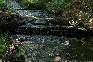
Our conversation reminded me of the fact that one of the 3 creeks on our property is what is known as a “blue line stream”.
Here’s what that means…
Our Current Situation
There are currently 3 creeks surrounding the “building envelope” on our 5-1/2 acres of land.
Thankfully, with all that shallow water, we’re not in a flood zone. (We checked with the county planning office before we bought the property.)
But one of the 3 creeks is what is known as a “blue line” stream. All they told us at the planning office was: “FEMA controls that creek and dictates building in, over, and around that particular body of water.”
At first, I figured it was because this creek served as a main channel for moving water at all times. I figured it must eventually link up with the river or something.
I’ve since learned the following about FEMA regulations and blue line creeks…
FEMA Blue Line Regulations
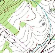
At the most basic level, “a blue-line stream is one which flows for most or all of the year and is marked on topographic maps with a solid blue line.”
According to a waterfront property & environmental lawyer:
- The Federal Emergency Management Agency aims to reduce losses through regulation of construction.
- FEMA regulations are enforced by local communities through building and zoning codes.
- The primary objective of FEMA is to elevate the habitable portion of structures above flood waters.
Summary
So, I guess for FEMA to designate one of the creeks on our property as a “blue line” stream, it originally had something to do with some combination of: surface flow, potential for flooding, and/or stormwater run-off.
In our case, (according to the Williamson County Planning & Zoning Dept. and the Stormwater Management Dept.) having a blue line creek on our property simply means that we cannot build (or disturb the land) within 30 feet of the centerline running through the winding, twisting, curvy stream of water. Period.
Thankfully, there’s still plenty of space for our house, driveway, and outdoor living spaces. (But let me tell ya, with property boundaries, placement of the creeks, and the hilly/rocky terrain in there… it hasn’t been easy to find the one spot where a 2,500-3,000 SF house can go!)
But all is well. It’s definitely been a learning process…
Oh yeah. If we wish to do something like “build a bridge over this creek” to create another access to our property (which we considered for a short time until we realized how expensive it would be), we simply have to complete an Application For Aquatic Resource Alteration Permit and submit it online. The Planning Dept. told us that chances were probably good that we could get permissions around this creek.